The Level Crossing Removal Project (LXRP) released design plans for the Bell to Moreland level crossing removal project on the weekend, including the Upfield Bike Path, a very busy arterial cycling route through Moreland that follows the railway line. The released plans include lots of glossy images, artist impressions, with greenery, some even with bikes and a few showing an ‘improved’ Upfield Bike Path.
So, we sat down and examined the landscape maps showing the purported route of the new and ‘improved’ Upfield Bike Path, put the artist impressions under a magnifying glass to see the good, the bad, and the plain ugly.
There are some positives such as the separated paths for walking and cycling between Munro street and Moreland Station precinct, and that should be acknowledged up front. But there are also some unknowns such as what priority for active transport at minor road crossings. There are also quite a few negatives, especially the Moreland Road and Bell Street crossings.
Bell street crossing and Coburg Station design still an ugly problem
.
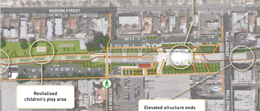
The Congestion point at Bell street with pedestrians and cyclists crossing at lights with greater than 200 active transport movements an hour during winter morning peaktime. Even greater numbers during summer.
The plans indicate that the Bikepath then diverts west around the station where conflict would occurr between cyclists at speed and people crossing between the station and station car park.
The legend indicates this path on the west side of Coburg station is a shared path. This path pits north-south cyclists against east-west pedestrian movement conflict. Pedestrians utilising the path for north-south movement will further add to the conflict issue.
Cyclists will lose the ‘Upfield wave’ effect with removal of the boom gates at Bell street, so some effort should be made to improve their journey at this conflict zone, but nothing is being offered as part of this design.
A cycling bridge over Bell Street and past Coburg station as part of the design would resolve all this perceived and actual pedestrian/cycling conflict and make the area safer for both cyclists and pedestrians and provide a safe crossing and flow to cyclists.
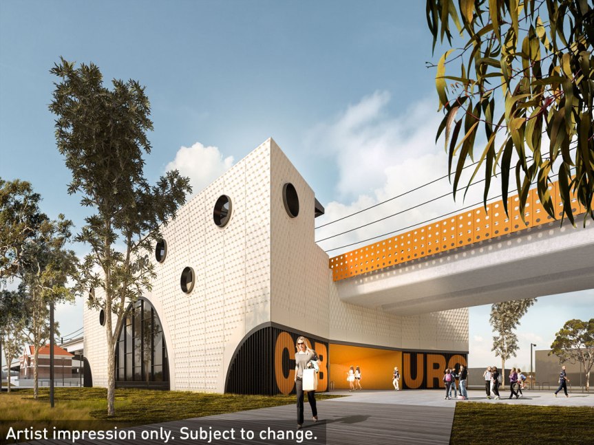
A cycling parent raises a valid question. Have LXRP really addressed this issue with their crossing design at Bell Street?
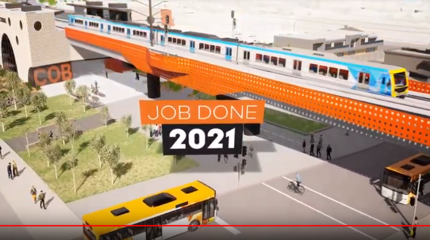
The Bike path then adjoins a walking path under the rail viaduct until Victoria street. This could result in pedestrian/cycling conflict issues of people wandering on the ‘separated’ bike path.
Imagine several commuter cyclists travelling at 20-25km per hour and children wandering across or along the path due to the unclear separation. See image below showing kids walking along where the two paths are side by side without any demarcation. Even with signage on the path, this could be a dangerous bit of design given the different needs and speeds of walkers and cyclists.
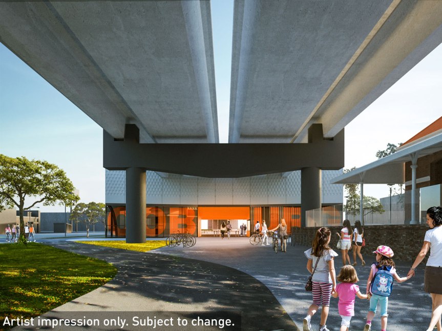
Separated bike path and walking path: Victoria street to Moreland Station
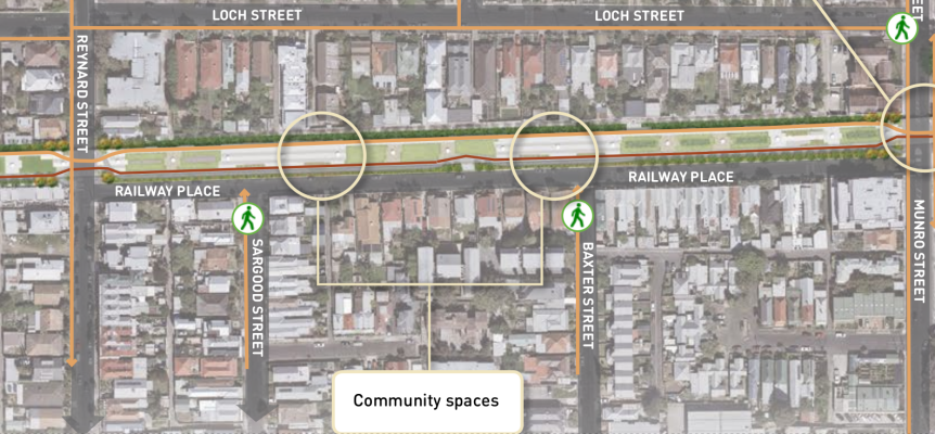
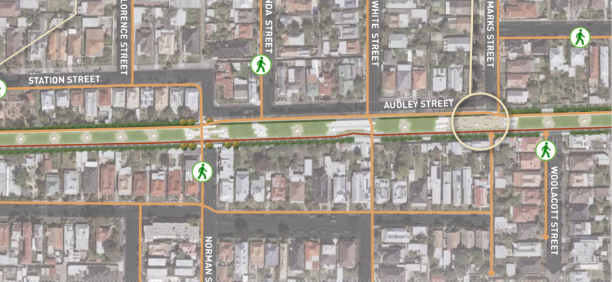
From Victoria street the Bikepath and walking path are separated. The bikepath remains on the east side of rail viaduct all the way to Moreland Station.
This stretch of separated path is fairly straightforward, as long as good sightlines are maintained for both cyclists and pedestrians who cross the cycling path.
The two paths converge together at Munro street and Reynard street crossings.
What priority will be given to pedestrians and cyclists over the vehicle traffic at these two crossings is at the moment unclear, an unknown. They are both nominally local roads. There is a strong argument that active transport should be given priority treatment at both crossings.
Munro street is used as a rat run to Bell street and has a considerable amount of traffic, often moving quickly at the current road crossing. A Traffic light crossing is probably needed at this crossing point, but the time cycle should be set to give priority for active transport. There should be an in-ground sensor to detect bike traffic to change the light cycle, with a ‘Beg’ button for pedestrians. There should even be consideration given to switch the priority around at night to give active transport a green light, with vehicle traffic needing to set off the light cycle from sensors buried in the road.
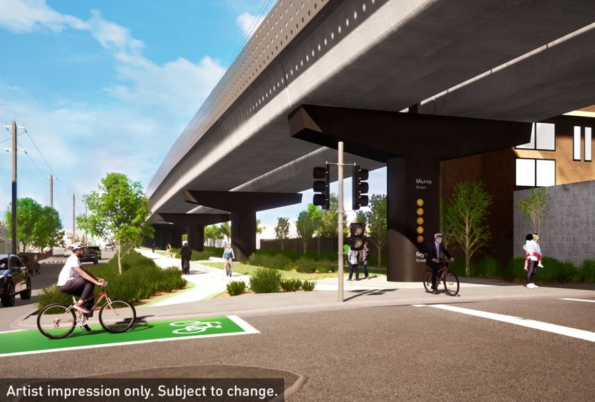
Some places actually install lights with priority for active transport.
Reynard Street has reduced vehicle traffic. A stop sign for traffic with a raised crossing highlighted in green or orange for cyclist and pedestrian priority should be strongly considered.
The separated bike path would need some signage warning pedestrians to look for cyclists when crossing, and cyclists should also be aware that pedestrians may cross.
Moreland Station and Moreland Road – congestion and conflict point remains
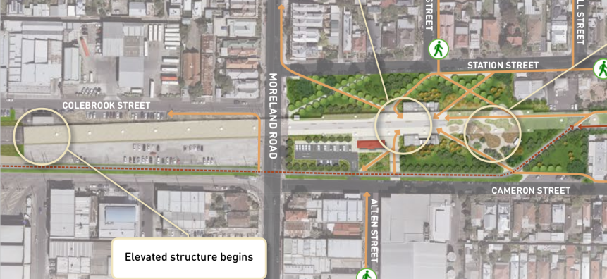
The dedicated bike path becomes a shared use path when it meets the Gandolfo Park. The bikepath passes the new Moreland Station following the same alignment as the existing path.
This is where increased pedestrian / cycling conflict is also a problem zone.
Priority for cyclists at the Moreland Station car park entrance is essential, with give way signs for cars and a highlighted raised path crossing the car park entrance.
Moreland Road and the Upfield Path has 250 cyclists per hour in the morning peak. There are high numbers of people walking west to east to either catch the tram or walk to Sydney Road.
The Moreland Road/Cameron Street intersection is a major congestion point and a conflict zone for pedestrians, cyclists and vehicles.
The path south of Moreland Road has been moved next to Cameron Street to align better on either side of Moreland Road. This is a big positive, but it introduces conflict between cyclists on the Upfield Bike path and cars entering the tram depot car park from Cameron Street. Give way signs for cars entering or leaving the car park should be mandated, along with a highlighted raised crossing on the bikepath for cyclists.
The tram stop on Cameron street, south of the Moreland Road intersection, is another conflict point between pedestrians and cyclists using the Upfield Path.
A simple cycling bridge over Moreland Road and past the station precinct would resolve the pedestrian/cycling/traffic conflict and enable smooth traffic flow for cyclists.
Cyclists will lose the ‘Upfield Wave’ effect from loss of the boomgates at Moreland Road, so a cycling bridge would be some compensation and maintain cycling flow.
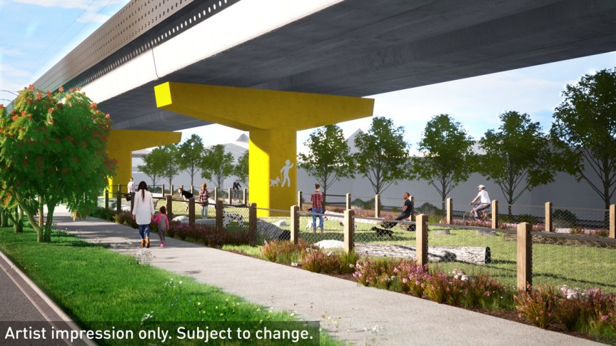
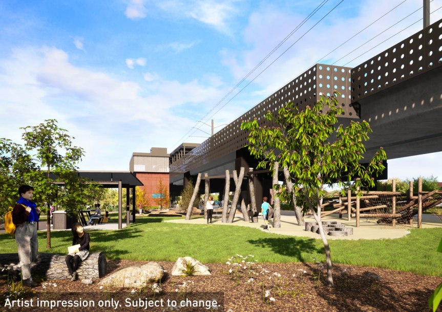
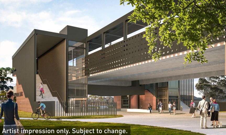
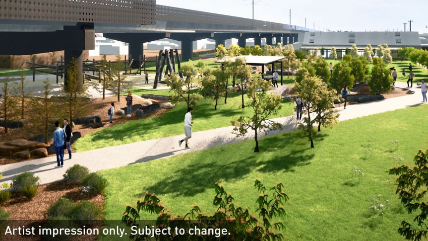
There has been some concern over particulate pollution from the elevated railway being the reason why BBQ facilities were not provided at Caufield Dandenong level crossing removal. It looks like from the below artist impression that Moreland might get a BBQ and picnic shelter on the east side before the station next to the Nature Play area. The Bike path will pass this point to the left of this image.
Elevated veloway versus two shorter cycling bridges
From the initial first consultation on level crossing removal we have argued there should be an elevated veloway from O’Hea Street to Tinning Street for 2.3 kilometers attached to the rail viaduct (First submission July 2018, Second submission June 2019).
We think this would resolve multiple conflict issues and future proof cycling on a main arterial cycling path. Cycling numbers are increasing in Moreland with cycling numbers on the Upfield path at Moreland Station doubling between February 2017 and February 2019. This trend is only likely to continue. We should be building the cycling infrastructure, such as a commuter veloway to match this trend.
We still need to have the ground level path for local cycling.
Short cycling bridges a solution to congestion and conflict
An alternative, and a substantial compromise, but one that tackles the essential pedestrian/cycling/vehicle traffic conflict zones at Bell Street and Moreland Road, would be to provide shorter cycling bridges for cyclists past these major congestion and conflict points.
The State Government and Level Crossing Removal Project needs to understand that the Upfield bike path is an arterial cycling route carrying thousands of cyclists everyday.
Level Crossing removal project should not be hindering this zero emissions sustainable cycling traffic but improving the cycling flow.
Community Feedback to LXRP highlighted active transport and cycling as top issue
The local community at the consultation sessions highlighted that providing major improvements to the Upfield path for cyclists and pedestrians was the number one issue. This is reflected in the LXRP own community feedback report (PDF).

LXRP have done a poor to mediocre design job so far in meeting what the community wanted with regards to cycling.
What LXRP have provided are some pretty pictures which do not resolve the congestion points and conflict zones.
Providing cycling bridges, or shorter elevated veloways, past Bell Street and Coburg station, and at Moreland Road past Moreland Station, would eliminate these major congestion and conflict points.
At public consultations LXRP provided statistics on car movements, train movements and station entries, but no information on active transport movements at Bell Street and Moreland Road and around the station precincts.
Active transport data was provided to LXRP by Moreland Council, so the data was available, but simply not shared with the public at the public consultations.
Improved cycling infrastructure mandated in legislation, LXRP design framework, Transport Department Policy
Legislation
Delivering cycling infrastructure improvements as part of major transport projects is mandated in the Transport Integration Act of 2010, and under LXRP’s own urban design guidelines.
LXRP design Framework
The Level Crossing Removal Authority Framework document, Urban Design Framework: Principles & Objectives, Measures & Qualitative Benchmarks (PDF) Version 4 (May 2018), states clearly that cycling paths should be enhanced to match desire lines and key flows:
M3.7 The design promotes direct, efficient, comfortable, safe and legible intermodal connections by: (2nd point) – Ensuring walking and cycling paths cater for desire lines and key flows
M4.4 Pedestrian and cycling overpasses are provided at strategic points relative to pedestrian movement patterns and the existing and proposed street and cycle networks; where applicable.
M8.2 The existing pedestrian and cycling network along the rail corridor and to the station precinct is maintained and enhanced, particularly strategically important cycling corridors (SICCs), priority bicycle routes, the principal pedestrian network (PPN) and pedestrian priority areas.
M8.3 Identified issues and barriers for cycling and pedestrian connection are addressed by improving conditions for pedestrians and cyclist equally with continuous, more direct, safe and high-quality routes. Space is allocated at an early stage and the need to re-allocate space for motorised vehicles to achieve a sustainable outcome is actively considered.
It is time for Transport Infrastructure Minister Jacinta Allan, and local Labor MP Lizzie Blandthorn MP ensure that cycling infrastructure is put in place as part of level crossing removal, commensurate with the community demand, the present cycling traffic and the strong trend of cycling growth in Moreland.
Department of Transport policy
We respectfully draw the Minister’s attention to the Transport Department policy with the Victorian Bicycle Strategy 2018-2028 available for download from the Transport Department Walking and Cycling page.
This clearly states:
“Major transport projects offer a valuable opportunity to improve strategic cycling corridors. This is because planning and building high-quality cycling infrastructure as part of a new project is less-disruptive and lower-cost than retrofitting it into an existing development.
“All major transport projects currently being planned and built such as the Level Crossing Removal Project and the West Gate Tunnel Project include substantial new and upgraded cycling infrastructure, including infrastructure to fill gaps in the strategic cycling corridor network.”
We ask nothing less than LXRP step up and provide the cycling facilities needed, and that the local community is demanding should happen as part of this project.
We don’t think the present designs have done justice to what should be provided in terms of cycling infrastructure and what the community is demanding be supplied.

2 thoughts on “The Good, the bad and the plain Ugly: Assessing Coburg level crossing removal and the Upfield Bike Path”